Collections record Beta
Collection Record Detail
Object Name
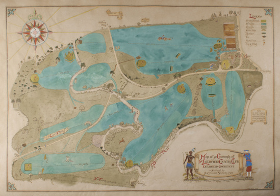
Map
Object Number
2013-131-1
Description
Hand drawn and painted ink and watercolor map depicting the grounds of the Litchfield Country Club. Map outlines the golf course and is executed mainly in greens and blues. A legend is located in the upper right corner. A compass showing the cardinal directions is drawn in the upper left corner. "Map of Ye Grounds of/ Ye LITCHFIELD COUNTY CLUB/ LITCHFIELD CONNECTICUT/ SURVEYED by/ Ye Columbia Students - 1924" in bottom right corner center on a drawing of an open scroll. A native American stands on one side of the scroll. A man in colonial dress stands on the other side of the scroll aiming a long rifle at the native American.
Category
Maker
Date Made
1924
Dimensions
22" H x 30" w
Materials
Social Tags (experimental)